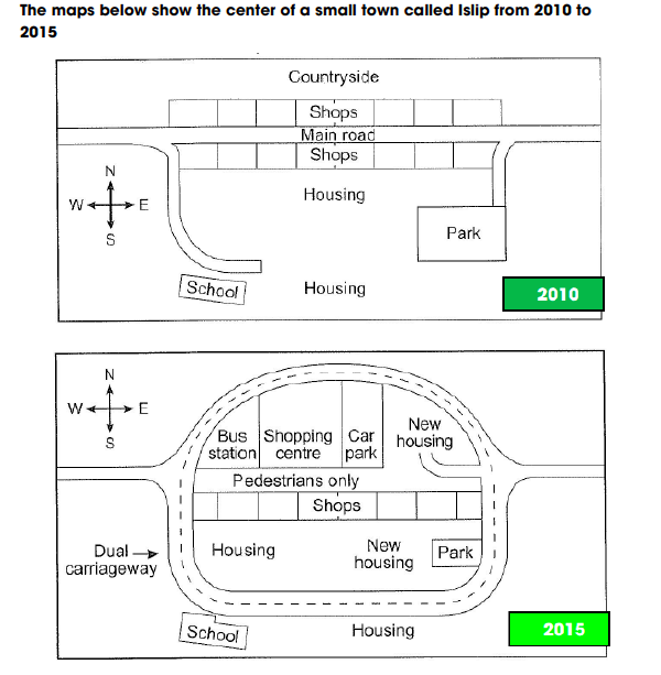
The maps below show the center of a small town called Islip from 2010 to 2015.
The pictures map illustrates the changing of a small town named Islip between 2010 to 2015.
Overall, there are some major changes in the constructions of several facilities during a five-year period.
In 2010, there was a main road running across the town which slipt Islip in two parts. The upper part of the map is constructed with a hall of shops, above the shops’ hall is the rural areas. To the south of the map, there is also a shops’ hall facing the northern one. At the back of the hall, there are two residential areas next to each other. To the west of the map, a park is connected with a side road which is linked to the main road. Last is the school, which is located on the left-hand side of the residential areas, it is accessible by a minor road that leads to the main road.
In 2015, there is some major modification throughout the town. The most noticeable is the main road, which had been turned into a dual highway that ringed Islip. Replacing the position of the main road, there is now a pedestrian sidewalk. The shop on the north has been demolished and been split into 3 facilities, which are the car park on the right and the bus stop on the left, between these two is the shopping mall. In addition, there is also a new accommodation which is accessible by a small road linked to the divided highway. On the south of the map, the park has been made smaller to make way for the new housing which was built right next to the old housing area. The school and the other old accommodation had been moved outside the highway ring. Relocated on the left bottom side of the map, the school is opposite the old housing area, the other old accommodation is placed faced the new residential area.
Hi, your report is not too bad, but there are two main issues. First, you should be describing the town itself, not the map. This includes using the cardinal directions north, south, east and west, instead of “on the right side of the map”. Possibly you could say something like “facing the shopping centre, the bus station is on the left”, but even that is not really the best because it is unclear which side is the “front” of the shopping centre. The other major problem is both of these maps show different time periods in the past, so simple past or past perfect should be the tenses used, not present. You also have a few places where you just gave the wrong facts, like saying “To the west of the map, a park is connected with a side road” - the park is located on the east, not the west. It is very important not to give incorrect facts, as these could really reduce your score. Here are some specific suggestions:
Dear Teacher,
I am a new user on your web and I am so surprised with your enthusiasm when you fixed carefully student’s writing task 1.
I appreciate your knowledge with figuring out these mistakes so can you help me complete my task in the same map?
Thanks!
The given maps illustrate the changes in the center of a small town called Islip between 2010 to 2015.
Overall, the residential, educational amenities, and utilities services have been significantly changed along a main road over the mentioned period.
In 2010, the long main road running from the East to the West divided a small town into two parts with few accompanied services along two sides of it. The figure has shown that while the housings and school and with the large additional park were on the right side of the road, only shops were located on the other side of the main road.
Looking especially at the strong development in 2015, the main road was replaced with Dual carriageway encircled around the area. Thus, there are some new zones were built with the Bus station, car park, pedestrians only, and with additional new housing among them. Although the shops, school, housings and park in the area have remained unchanged, the park has narrowed.
These maps illustrate the changes in the center of a small town called Islip between 2010 and 2015.
Overall, the residential, educational, and utility facilities along a main street have changed significantly over the period.
In 2010, the long main street running from east to west divided the small town into two parts with few accompanying services along either side of the street. The figure shows that the residential houses and the school with the large additional park were located on the right side of the street, while only stores were located on the other side of the main street.
Especially in view of the strong development in 2015, the main road was replaced by a two-lane road that surrounds the area. This created some new zones with a bus station, parking lots, pedestrian areas and additional new housing. Although the stores, the school, the residential buildings and the park in the area have remained unchanged, the park has become narrower.