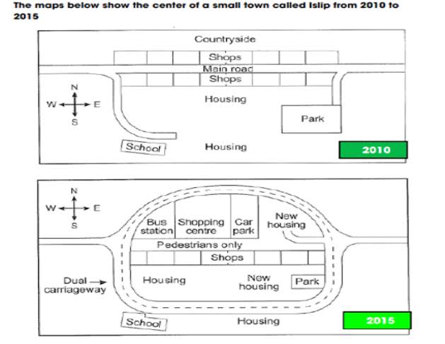
The 2 given pictures illustrate the center of Islip town in 2010 and in 2015.
Overall, it is clear to see that there are several significant changes from 2010 to 2015, to wit: the year 2015 witnessed a big development by a new dual carriageway and more infrastructures in this town than the year 2010.
In 2010, there still had rural areas in the North of the town center. In addition, shops were located in both sides (Northern and Southern) of the Main road which run throughout the town from west to east. Behind the shops in the Southern, there are 2 housing estates. One was located in the middle of the town, near a park in the East; another one was a long distance away the Main road but it was next to a school in the West.
5 years later, there was an appearance of a Dual carriageway that surrounded almost the whole infrastructures of town center, excepted the School and the housing estate was on the right – hand of the school. The Main road was no longer used for vehicles instead, it was used for pedestrians. The shops in the North were knocked - down and developed a bus station, a shopping center, a car parking and a new housing estate respectively from West to East. The Housing estate in the middle of the town was relocated to the west and a new housing was built between the park and the relocated housing estate.
Hi, I think this report does a pretty good job of describing the two maps. You do have quite a few mistakes in tense though. Both maps show the town in the past.
When you compare the 2015 map with the 2010 map, you often have to use past perfect to show that something happened further in the past than something else - “By 2015, the main road had been converted to pedestrian use only.”
Also try to use some synonyms for “housing estate”, like just “houses” or “residential areas”. Also, make sure to avoid saying the changes took place in 2015.
We don’t know exactly when they happened, just sometime between 2010 and 2015, so use phrases like “by 2015”. Generally north, south, east, and west are not capitalized unless they refer to specific regions of the world: When Do You Capitalize Directions? - Quick and Dirty Tips
Sometimes these maps and diagrams will have “creative capitalization”, but in your report you must stick to standard English rules. Here, the only proper name is “Islip”, so that would be the only name capitalized. Here are some other suggestions:
Hi sir, could you please correct mine too? And give a band score roughly so that I can try to improve.
Thanks.
IELTS Writing Task 1 – Maps
The two maps illustrate the changes happened in a little town called Islip over a period of five years starting from 2010 to 2015.
Overall, the structure of the main road was completely changed so that pedestrians won’t get affected while crossing the road and also there seemed to be an increased amount of shopping centers and housing units.
There seemed to have countryside on the north during 2010 which was then replaced by constructing a road that connects both the western and eastern end of the same road. Furthermore, accessing through the center of the town using the main road was restricted and was turned into pedestrian-pathway.
Also, there seemed to have a lot of developments which include bus station, shopping centre, car park and new housing inside the ring road. In addition to this, the road between the school and park was extended so that it can connect both the places. Then, the shops near the countryside were also demolished.
@Natalia_Polteva Hi mam, could you correct it and give me an approximate band score? So that I could try to improve.