Dear Teacher,
Please help to correct and give some feedback for my writing IELTS task 1. Thank you very much!
TASK:
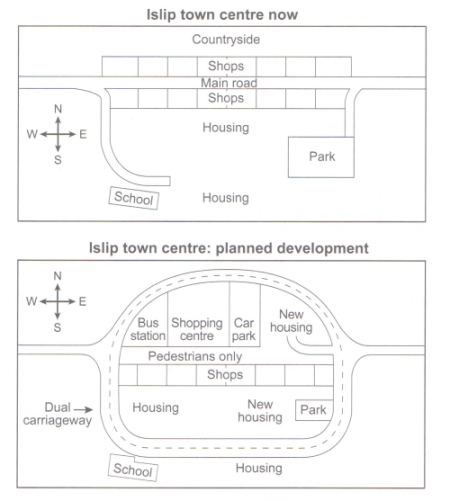
The maps below show the centre of a small town called Islip as it is now, and plans for its development.
Summarise the information by selecting and reporting the main features, and make comparisons where relevant.
The two maps illustrate the central area of the Islip town at the moment and its forecast development. It is clear that the inner town is expected to have significant modifications with more facilities and the introduction of a dual carriageway.
It is noticeable that the Slip town centre is currently located in the countryside, having a main road crossing from west to east. However, in the future, a dual carriageway will be built to create a ring around the town, and the main road will be pedestrianised.
With regard to the inner town, a row of shops along the north side of the main road as they are now will be demolished; other facilities, namely a bus station, a shopping centre and a parking space are planned to be constructed. It is predicted that a new area of accommodation will be built. As a result, the current park nearby will be reduced in size in the future. Interestingly enough, a chain of shops situated in the south side of the main road will be maintained.
Wow, this is a great report. Your description is extremely clear and detailed, with effective organization and great use of vocabulary, like pedestrianised. There were only a few errors I was able to catch. I think this would surely score at least a band 7.
The maps illustrate the current and some proposed changes of Islip town.
Overall, new spots are anticipated to replace shops and countryside at north side and some minor altercation at south.
Currently, there is the main road which stretches from west to east. Also, row of shops are can be seen at north and south of the main road. Although the north of the main road is mainly countryside, a big area at the south part is covered with accommodations. Moreover, we can see that school is at the south-west of housing and park at east side which links path to both places from the main road.
Moving on to the projection of Islip town, the middle of road is expected to be removed within certain length. Instead, pathways will be created for pedestrians while bus station, shopping centre, car park, and new housing would also take over the countryside and shops respectively from west to east. Taking into consideration, shops that are affected after the creation of pedestrian road are relocated after demolishing housing in the middle. Not to mention the park will be narrowed in order to build new housing property. In fact, circular dual carriageways is formed along the new facilities connecting the current road at school and park.